
There is a reason that Google Maps is one of the most prominent and prolific apps today. It has become more than just getting us from one place to another.
This is no mobile Garmin! It has many powerful and useful features that can help you do things you would normally not expect a simple GPS mapping device to do.
Google Maps offers a range of features that go beyond displaying visuals of your destination. It provides travel times for various transportation options and walking, suggests potential destinations, and incorporates augmented reality features.
Amidst these, there are additional interesting and highly useful features designed to enhance our travel experience. Some of them are more than useful, and they are even fun!
We’ll look at the top 20 Google Maps tips and tricks you can use to improve your Google Maps experience.
As part of our Google Maps tips, we used an Android phone. The Google Maps iOS app is very similar to the Android app, so you should have no problem following along.
Best Google Map Tips and Tricks
So, here are 20 of the best Google Maps tips and tricks to help take your driving experience to the next level.
Offline Map Access
The shortcoming of smartphone apps is that they generally rely on internet service to be able to provide you with the information you need.

Unfortunately, you may be traveling to a place with poor or weak mobile connectivity. It is also likely to be where you need the Maps app the most. Google Maps is prepared for this possibility by providing offline access to maps.
Research the map and directions ahead of time, then tap on the portion of the map with your intended destination.
You will be able to download the map to your device, assuming you can accommodate the size of the files.
Once downloaded, you can access the locally saved map and directions under the offline maps section of the Maps app or from your downloaded storage.
Drag & Drop Direction Changes
There is more than one way to get from point A to point B. Google Maps makes figuring out an alternate route simple by allowing you to move the plotted course with your mouse or finger on the map.
You click/press on the blue route line, hold the action, and drag the route in any direction. The blue line will dynamically adjust to an alternate path.
If you pull it too far away, it will still adjust. Keep in mind that it typically defaults to the shortest ride (timewise), though if you prefer a more scenic route or minimal highway travel, you might have to travel a bit longer.
See this guide if Google Maps is not showing the route or keeps crashing on your smartphone.
Voice Command Based Interactions
When driving, not paying attention to the road is not only discouraged, it’s outright unsafe. Some states have even outlawed any activity that includes holding a physical phone in your hand.
Luckily, Google Maps allows users to interact with the app vocally. By saying, “Hey Google,” you can activate the app’s “listening” ability and make inquiries about your topics of concern.
For example, if you cannot look at your phone, you can ask Google Maps what your next turn is, how far away you are from your destination, and if there is any traffic ahead.
Maybe you are running low on gas, need food, or are in an unfamiliar area. You can ask Google Maps where the closest gas stations or restaurants are, and they will appear on the map display.
Your driving experience will be more pleasant and safer since Google Maps can talk and give directions.
Speedometer
Sometimes, you try to follow a map so closely that your eyes move between your device and the road. This may cause you to forget to glance at your speedometer.
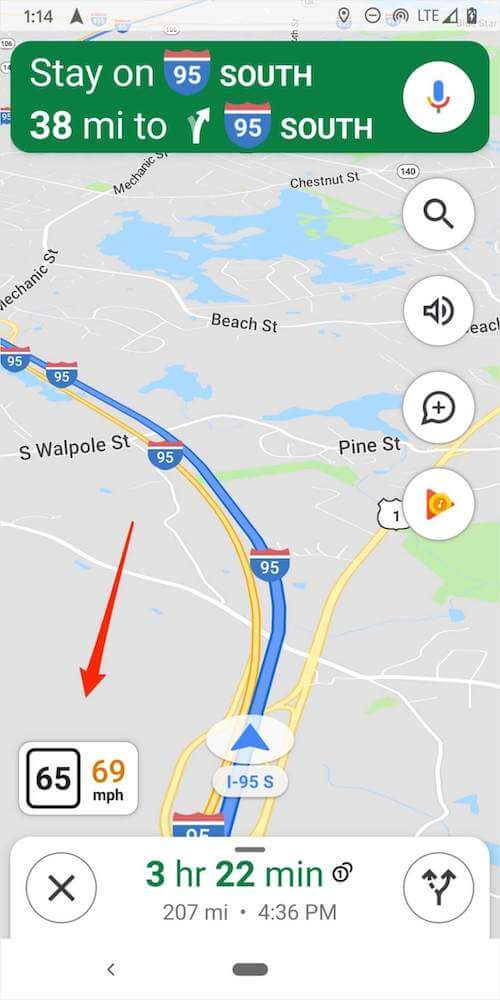
Google Maps features a speedometer feature that can be enabled under the Navigation Settings.
This will put a speedometer in the corner of your map so that your speed will also be in your direct line of sight when you look at your map for directions.
Multiple Stops
Most of us have had to take a car ride that involved multiple stops. If you are traveling in an area you are not inherently familiar with or is traffic-prone, consider leveraging the ability of Google Maps to allow multiple stops along your route.
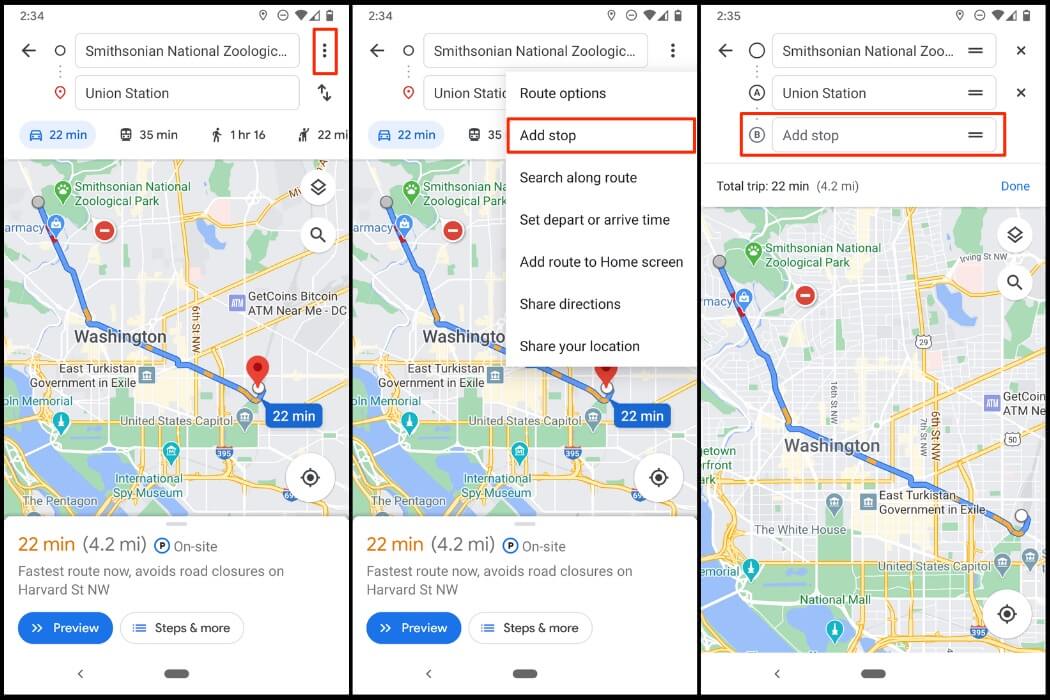
This can be done by clicking the three dots next to the ‘from’ location field and selecting the “Add stop” feature. This will tack on an additional destination field to your map.
That way, you can set multiple destinations in the order you need to reach them or change the order of destinations to suit your trip’s needs.
If you have a busy day of traveling with many stops, don’t worry; Google Maps allows you to add many stops to one trip.
Save Your Parking Location
One of the most annoying things about parking, especially in a busy city you may not know like the back of your hand, is remembering where the parking location was.
By tapping on the location icon, you will receive a drop-down menu. One of the options will be “Save your parking.”

Once you choose it, you can save your parking location so that when you are ready to find your vehicle’s parking spot, you can refer back to your saved location. You can even use your device’s Google Assistant to help guide you to the parking spot.
While saving your geographical parking spot, you can even leave notes. This includes storing photos of landmarks nearby.
If you are parked in a timed area, your notes can include how much time you have remaining, and your device will notify you when the time gets close to expiring.
Find Locations Near You
The same popup menu that brings you the parking saving feature will also include a “search nearby places” feature (as seen in the above picture).
If you are looking for a new place to dine or simply exploring your options for shopping, you can find many retailers and services around your current location by selecting this feature.
They will populate right on your map. You will not only be able to click on their location and get directions to their front door, but you will also have the ability to go to their website or contact the business right from your Google Maps app.
Location Sharing
You might be traveling to a new destination and might have loved ones concerned with your safety, or perhaps a friend is awaiting your arrival and trying to get a bunch of things done before you get there.
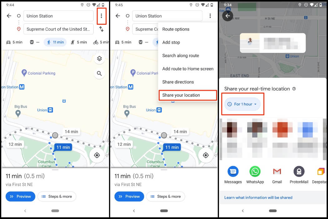
Google Maps helps ease nerves and time plan accordingly by sharing one’s geographical location on Google Maps.
To do this, tap on the three dots at the top right corner of the screen to bring up the menu. Then, choose the location-sharing option.
You can either set it to report your location perpetually (until you turn the feature off) or share it for some time (like an hour).
You can then select who you would like to share it with. That party will be able to look at the Google Maps app and see your current location.
Add Traffic, Crash, Road, Construction Reports
Have you ever sat in traffic and wished that someone would have let you know that there was a traffic jam that would have allowed you to choose a different route?
Waze has long offered app users the ability to report traffic. Still, now Google Maps also allows you to spare other drivers the headache of running into unexpected traffic.
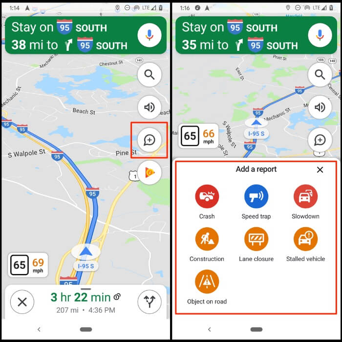
If other drivers see the traffic, they try to avoid this road. This helps them as well as anyone who does not have a choice but to travel on this road as the amount of traffic backed up will end up being less.
You can do this by clicking the “plus” icon on your navigation screen and clicking “Add a report” from the selection options.
You can then signify if there is a slowdown, an accident, or some construction causing lane closures and bottlenecks in the flow of vehicles.
Street View
Need to know some landmarks to find an address? Are you interested in the look of a particular area you will be traveling to? Perhaps you want to see what is down the street.
In the years that Google Maps Street View feature has been operational, Google has amassed a ton of photographic references for streets.
Not only did Google cars travel many roads and capture 360-degree, panoramic views of streets, but it has also done so several times in most cases.
That means you can scroll through a historical archive to see how a particular area has changed over time.
Create Private Maps
Google Maps allows you to create your own customized maps, where you can name particular points on the map to your liking and even create customer travel routes (car, public transport, or walking).
You can do this by accessing the menu for Maps from the “Your Places” menu. From there, you can select the Create Map feature. You can save these maps and even share them with others.
12. Get an Idea of Parking Availability
Anyone who has ventured into a big city or an otherwise bustling area has likely cycled through multiple streets in a seemingly endless loop in a dire search for available parking.
Doubtless, this annoying adventure has sometimes made us late for our scheduled meetings or events.
Google Maps provides a helpful indicator that will let you know whether parking availability is limited. That way, you will know to arrive earlier to give yourself ample time or opt for public transportation.
Stream Music
A drive with a map that tells you directions doesn’t have to be quiet to afford the device issuing directions and nothing more. Google Maps has now incorporated music streaming services into the Maps experience.
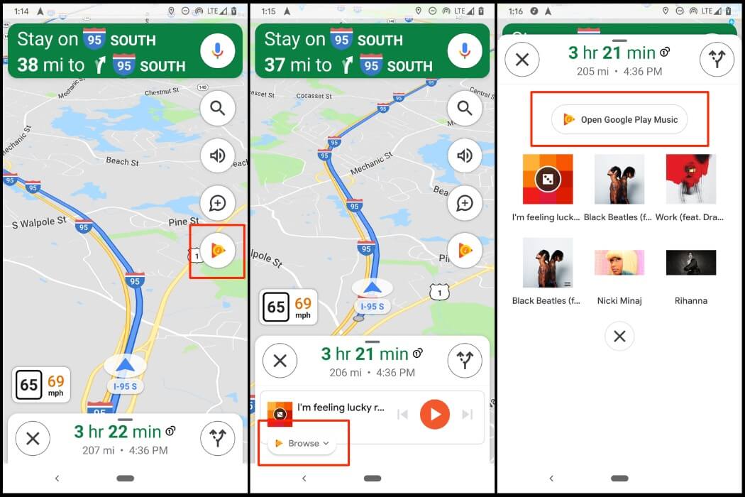
The app has now partnered with Google Music, Spotify, and Apple Music to allow you to stream your favorite songs and podcasts during your trip.
When the map is ready to speak, the volume of the music lowers automatically to make the directions clearer, then comes back as the prominent sound.
This option is under the Navigation Settings, where you can enable the connection through Music playback controls on iOS and Show media playback controls on Android.
For Android phones: Settings > Navigation Settings > Show Media Playback Controls. Then, choose your preferred media player (Spotify or Google Play Music).
On an iPhone, follow these steps: Settings > Navigation > Music Playback Controls > Then, connect the media app of choice (unfortunately, there’s no Google Music option; it’s either Apple Music or Spotify).
Find EV Charging Stations
Electric vehicle technology is more prominent than ever before. The one concern many drivers have is that these vehicles must be charged regularly to function.
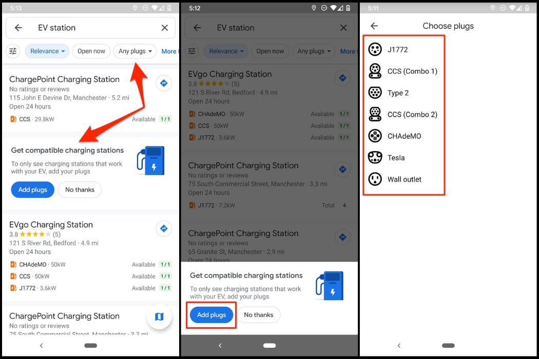
However, finding EV charging stations in an area that is either unknown or lacking sufficient charging equipment could be an anxiety-inducing endeavor.
Since Google Maps has the nearest gas stations available, they felt it was only fair to have EV listings included.
A simple search for “EV stations” will generate a list of the nearest charging stations, with information about the station’s location, types of ports used, and charging speeds. There are also photos and ratings from other drivers of the quality of EV services.
You can also filter out the results by adding your plug types. These include J1772, CSS (Combo 1, 2), Type 2, CHAdeMO, Wall outlet, or Tesla’s proprietary plug type. That way, you’ll only see charging stations that work with your electric vehicle.
Request a Ride
If you are looking to hail an Uber or a Lyft driver, take note of the icon of a person waving their hand when you search for a specific place on a map and tap the Directions button. The icon appears between the person riding a bike and the pedestrian.
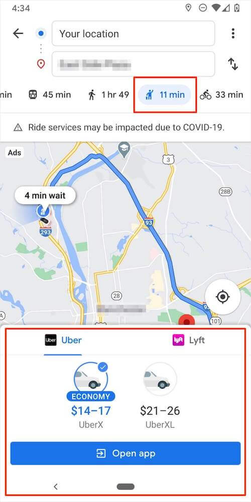
Clicking on this icon will provide service information, including wait times and current prices. You can begin your Uber or Lyft ordering process from the Maps app for added convenience.
Traffic Estimation
Traffic is nearly guaranteed in certain parts of the world at certain times of the day. In other places, it is common on certain streets or stretches of roads. Google Maps uses this knowledge to analyze and estimate typical traffic times.
When you look up your desired destination, you can click the down arrow next to it and note a line that says “Leave Now,” “Depart By,” and “Arrive By.”
Using these time markers, you can estimate the traffic conditions you will encounter around that time of travel along the specified route.
Public Transportation Info
Believe it or not, many people utilize Google Maps to find times and optimal public transportation strategies.
Google Maps can tell you pricing information, best deboarding areas, platform numbers at airports, and live updates on the status of buses along your route.
This can certainly lessen the uncertainty of travel you rely on but do not have any control over.
Night Mode
Google Maps features a very helpful “night mode” that can be used to reduce eye strain.
Rather than a white background with many colors, which would particularly distract drivers at night, night mode uses a dark background while still showing all the pointers, markers, and destinations.
This can be enabled from the Navigation settings, where the color scheme can be changed to “night.” This makes the view of the map easier on the eyes, even when used during the daytime hours.
Save Money
You can save money by using Google Maps. If this sounds odd, think about driving through tolls for a moment. Google Maps can allow you to select routes to get around or bypass most or all of the tolls you might have otherwise encountered.

When you select your destination and tap “Directions,” you can choose “Route Options.” In this menu, you can check off preferences, such as avoiding tolls or using ferries and highways.
Advanced Gesture Control
Are you not a fan of excessive phone handling when you need something detailed about the map?
No worries! Google Maps has certain built-in controls that simplify some of the process’s more hand-intensive parts.
You can zoom in on a location by double-tapping a spot on the map, spin a map with your index finger, and even view the “flyover” illustration layered with three-dimensional buildings.
One more helpful tip: If you hold the “Directions” button down, you will be taken directly into the device’s navigation mode. All of these things take two fingers or less to handle.
Final Thoughts on Google Map Tips and Tricks
I hope you find these Google Maps tips and tricks useful.
Now, over to you. What are your favorite Google Maps tips that you use all the time? If you know some tips that we left out on this guide, please share them with us.
If you have any feedback or questions, please don’t hesitate to comment below.